DEM vs DSM vs DTM: What's the Difference?
DSM (Digital Surface Model) captures the top surface including buildings and vegetation, DTM (Digital Terrain Model) is the bare-earth ground, and DEM (Digital Elevation Model) is often used as the general term covering either. They sound alike and are often used interchangeably, but getting them straight matters, because using the wrong one can put real error into a volume or a drainage plan.
DSM — Digital Surface Model
A DSM captures the top of everything on the ground: bare terrain plus buildings, trees, vehicles and other objects. It is usually what you get first from photogrammetry or LiDAR, because sensors see the top surface.
Use a DSM when the objects matter — line-of-sight over rooftops and canopy, volumes of piles and structures, or urban and forestry work.
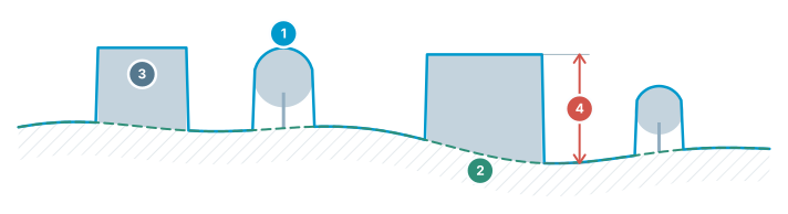
DEM / DSM / DTM
Three different surfaces of the same terrain — which one to use, at a glance.
- DSM — top surface — includes buildings, trees and structures
- DTM / DEM — bare earth — real ground with objects removed
- Objects — present in the DSM, absent in the DTM
- Difference = object height — building/tree height comes from this gap
DTM — Digital Terrain Model
A DTM is the bare-earth surface with buildings and vegetation removed. It represents the ground itself, which is what most engineering work references.
Use a DTM for earthworks, cut/fill, grading, drainage and contours — anything that should follow the terrain rather than the objects sitting on it.
DEM — the general term
"DEM" (Digital Elevation Model) is commonly used as an umbrella term for a gridded elevation model, which may be either bare-earth or surface depending on how it was produced.
When precision matters, say DSM or DTM. When you just mean "a grid of elevations", DEM is fine.
A quick way to remember it
DSM = surface (with objects). DTM = terrain (bare earth). DEM = the general elevation grid. If someone hands you a "DEM", it is worth asking which one they mean before you compute a volume with it.
| Model | What the surface includes | Use it for |
|---|---|---|
| DSM — Digital Surface Model | The top of everything on the ground: bare terrain plus buildings, trees, vehicles and other objects. | Line-of-sight over rooftops and canopy, volumes of piles and structures, urban and forestry work. |
| DTM — Digital Terrain Model | The bare-earth surface, with buildings and vegetation removed. | Earthworks, cut/fill, grading, drainage and contours — anything that should follow the ground. |
| DEM — Digital Elevation Model | Umbrella term for a gridded elevation model; bare-earth or surface depending on how it was produced. | Fine when you just mean a grid of elevations — ask which one it is before you compute a volume. |
Frequently asked questions
What is a DSM (Digital Surface Model)?
A DSM captures the top of everything on the ground — bare terrain plus buildings, trees, vehicles and other objects. It's usually the first output from photogrammetry or LiDAR, since sensors record the top surface. Use it when objects matter: line-of-sight over rooftops or canopy, volumes of piles and structures, or urban and forestry work.
What is a DTM (Digital Terrain Model)?
A DTM is the bare-earth surface with buildings and vegetation removed, representing the ground itself. It's used for earthworks, cut/fill, grading, drainage and contours — anything that should follow the actual terrain rather than the objects sitting on it.
What does DEM (Digital Elevation Model) mean, and how does it differ from DSM/DTM?
DEM is commonly used as an umbrella term for any gridded elevation model, which may be either bare-earth or surface depending on how it was produced. Say DSM or DTM specifically when precision matters, and use DEM when you just mean a generic grid of elevations.
What's a quick way to remember the difference between DEM, DSM, and DTM?
DSM = surface (with objects), DTM = terrain (bare earth), DEM = the general elevation grid. If someone hands you a "DEM," it's worth asking which one they mean before computing a volume with it.
Open DEMs, DSMs and DTMs in STREAM
Native Windows · fully offline · free beta