How to Design a Mine Haul Road
A haul road is designed like any other road: decide where it goes, decide how steep it may be, decide how wide it has to be — then find out what those three decisions cost in earthwork. What makes a mine road different is that the trucks are heavy, the geometry is unforgiving, and the ground you are designing on is re-surveyed every few weeks. This is the order the work is actually done in.
Start from the ground you surveyed
Every quantity in a road design is measured against a ground line, and that ground line has to be the real one. On a mine site it comes from the terrain model built out of the latest drone or LiDAR survey, not from a design surface drawn two years ago.
This matters more than it sounds. If the ground line at a station is half a metre out, the cut area at that station is out with it, and the error carries all the way through to the quantity table. Designing directly on the DEM you already have removes the step where that drift creeps in.
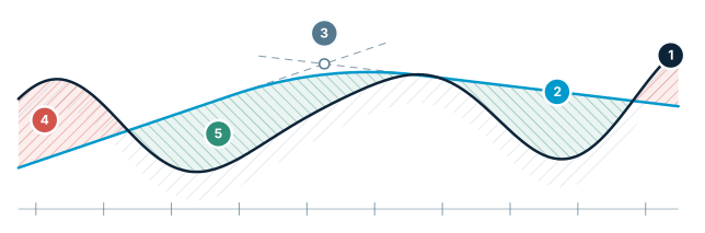
Road profile — grade, vertical curve, quantities
The ground line comes from the DEM, the grade line from tangents and a vertical curve. Cut and fill are the difference.
- Ground line — existing terrain read from the DEM
- Grade line — the design profile
- Vertical curve — the parabola easing two grades together (PVI)
- Cut — ground sits above the grade line
- Fill — ground sits below the grade line
Horizontal alignment: where the road goes
The horizontal alignment is a series of straights joined by circular curves. You place the intersection points on the terrain, set each curve by radius, and add clothoid transitions where a vehicle needs distance to build up cross slope.
The minimum radius is not a matter of taste — it is set by the largest truck that will use the road. Fixing that limit before you start drawing means a curve that is too tight shows up as a listed violation rather than as a problem discovered by a driver.
Vertical profile: how steep it may be
The vertical profile is defined by grade change points, the grades between them, and the vertical curves that round off each change. The ground line underneath comes from the terrain model, so you can see exactly where the profile is cutting and where it is filling as you drag it.
Grade is the number that gets argued about. In the United States most states have long used 15% as the ceiling for surface mine haulage roads, but that is a limit, not a target — sustained operating grades are normally well below it, because a road at the legal maximum costs fuel, brakes and tyres on every trip.
Typical section: width, shoulders, cross slope
The typical section is what turns a line into a road: carriageway width, shoulders, and the batter slopes that carry the formation out to meet the existing ground in cut and in fill.
Through curves the section is rotated so the road banks into the turn. Whether the rotation happens about the axis or about an edge changes the levels along the whole transition, which is why superelevation is defined as part of the section rather than patched in afterwards.
Earthwork: cut, fill and the balance
Once alignment, profile and section exist, the earthwork is arithmetic. A cross-section is taken at each station, the cut and fill areas of that section are measured against the ground line, and the volume between consecutive sections follows from those areas.
The station-by-station table is what gets checked and paid against. The mass haul view sits on top of it and answers a different question: not how much material there is, but where it has to go — which stretches balance within themselves, and which have to import or waste.
Check it before it is built
Maximum grade, minimum radius and sight distance are the three limits worth encoding before the first line is drawn. A design that re-checks them on every edit tells you the station where a limit is broken and by how much, while the geometry is still cheap to move.
The alternative — checking at the end, or on site — is how a road ends up with one curve nobody can drive at full load.
Frequently asked questions
What are the main steps in designing a haul road?
Set the horizontal alignment on the surveyed ground, shape the vertical profile against the ground line read from the terrain model, define the typical section with its width and batter slopes, then take cross-sections at each station to get the cut and fill quantities.
What is the maximum grade for a mine haul road?
In the United States most states have long used 15% as the ceiling for surface mine haulage roads, but that is a regulatory limit rather than a design target — sustained operating grades are normally well below it because a road at the maximum costs fuel, brakes and tyres on every trip.
Why should a haul road be designed on the surveyed terrain rather than an older surface?
Every quantity is measured against a ground line. If the ground line at a station is half a metre out, the cut area at that station is out with it and the error carries through to the quantity table, so designing directly on the current terrain model removes the step where that drift creeps in.
What is a mass haul diagram used for?
The station-by-station quantity table says how much material there is; the mass haul view answers where it has to go — which stretches of the road balance cut against fill within themselves, and which have to import material or waste it.
Sources
Design your haul road in STREAM
Native Windows · fully offline · free beta