VOLUME / CUT-FILL
Cut and Fill Software for Earthwork Volume Calculation
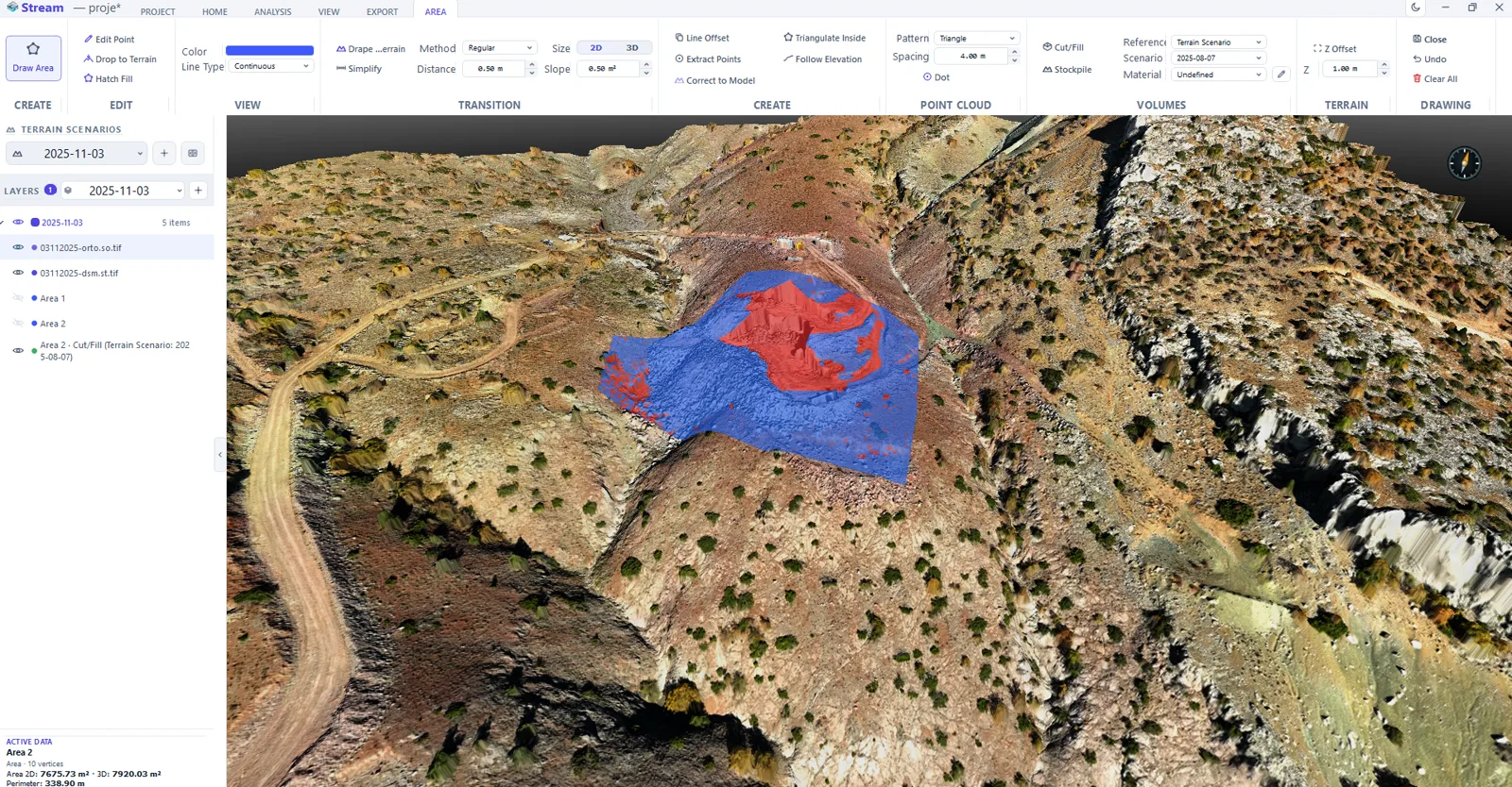
STREAM is cut and fill software that computes earthwork volumes directly on your DEM. Choose the reference — the real terrain, a flat design level, or another surface — and get cut and fill volumes with a clear heat map showing where material is added or removed.
What is cut and fill?
Cut and fill is the volume of earth that must be removed (cut) or added (fill) to reach a target surface. It is the core quantity in grading, road and mining earthworks.
The result depends entirely on the reference you compare against. STREAM lets you pick the reference explicitly so the numbers match your design intent.
Cut / Fill — three reference modes
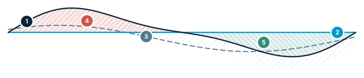
Same terrain, three references → three different volumes. The most confusing point for users.
- Existing terrain — the surveyed surface
- Flat level — a fixed design elevation
- Reference surface — another scenario or design
- Cut — above the reference → removed
- Fill — below the reference → added
Cut and Fill Software in STREAM
Four reference modes
Compute cut/fill against a surface through the area's own corners, a flat design level, its minimum, or another terrain scenario — you choose the datum.
Cut/fill heat map
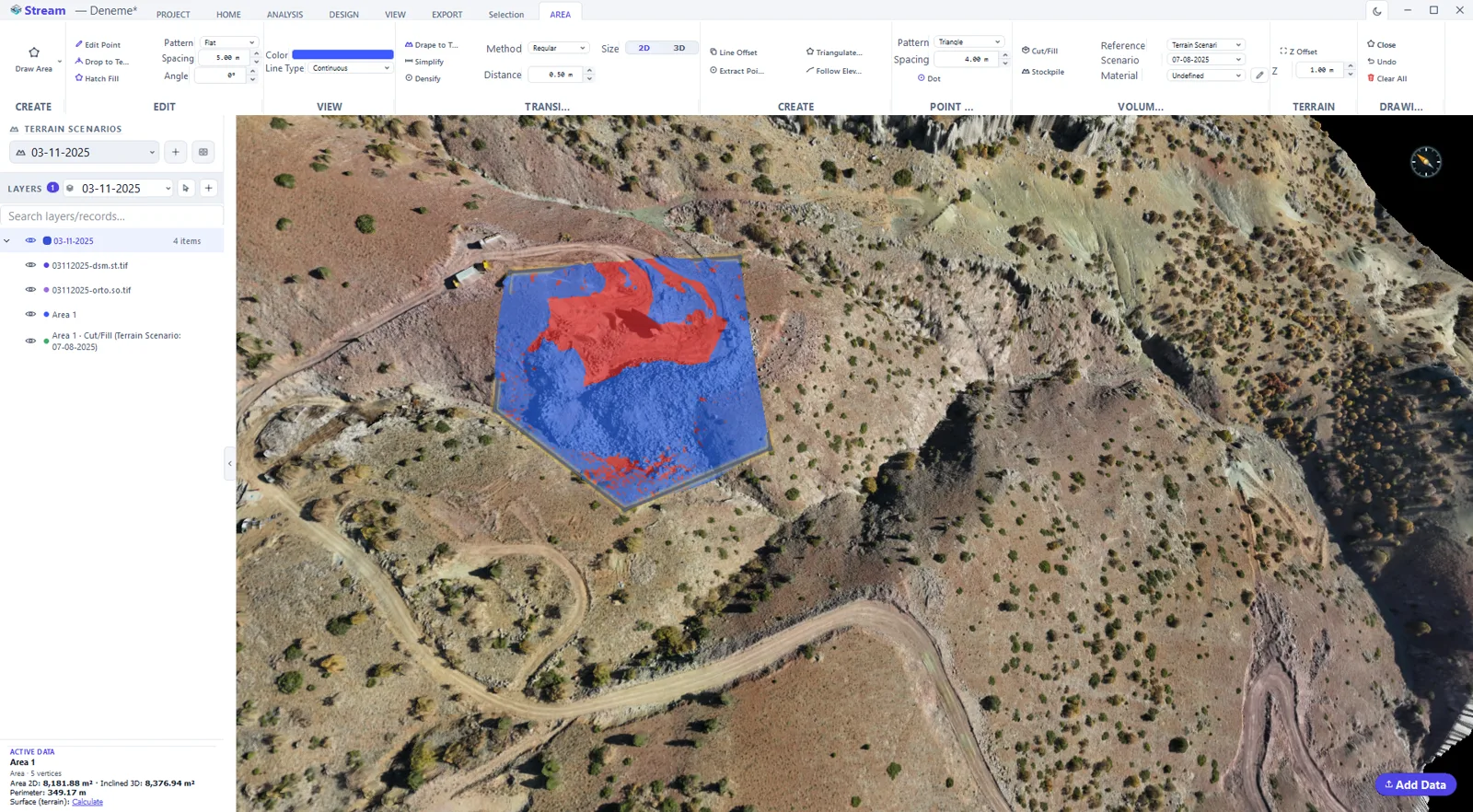
See exactly where cut and fill occur as a color overlay on the terrain, not just a single number.
Between two scenarios
Compare two terrain states (before/after) and get the net volume difference with cut and fill separated.
Export the result
Save the cut/fill heat map as a GeoTIFF raster or export figures for your report.
Switch the reference without re-exporting
Most cut and fill software locks the calculation to one fixed reference surface. STREAM switches between the live terrain, a flat design level, or a second scenario in the same view — every calculation runs on the DEM you already loaded.
Four things leave with one calculation
The cut and fill volumes, a GeoTIFF heat map raster, a station-by-station schedule as CSV or Excel, and the cross-section and long-section drawings as DXF — plus a signable PDF report and a scaled map sheet if the result has to be handed to someone outside the software.
Elevation band report
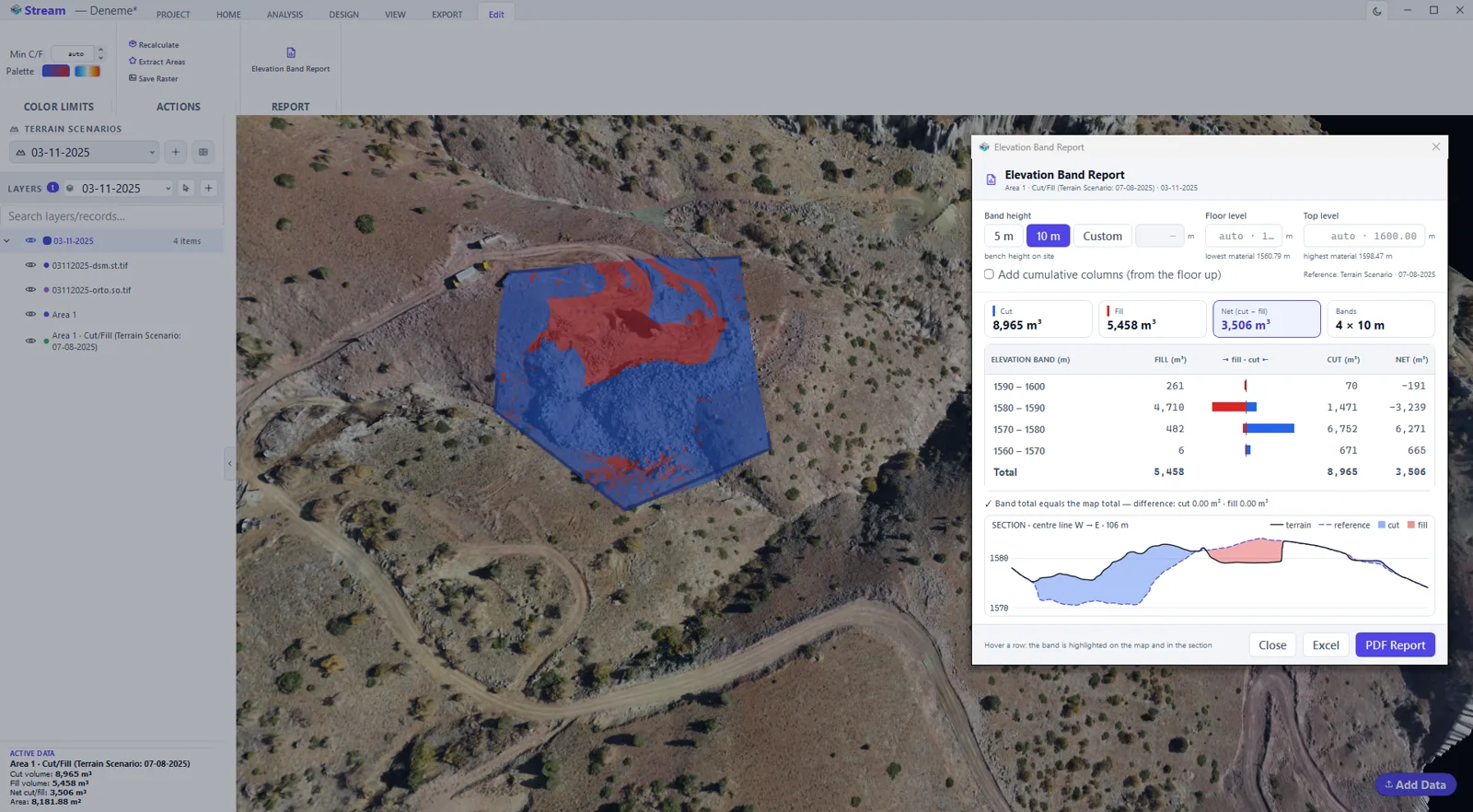
Split a cut/fill map's volume into elevation bands: you choose the band height, the floor and the top level, and a table shows how much cut and fill lies at each elevation, with optional cumulative columns, an elevation–volume chart and a mid-line section. Hover a row and the band lights up on the map; export the table to Excel or a signable PDF written from the same numbers.
In the product
How to calculate cut and fill in STREAM
- 1
Load the terrain
Open the DEM of the site (GeoTIFF), or import a LAS/LAZ point cloud and let STREAM rasterize it to a surface.
- 2
Draw the area
Outline the region that is being excavated or filled. The calculation runs inside that boundary.
- 3
Choose the reference
Decide what the terrain is measured against: the live terrain, a flat design level, or a second scenario such as an earlier survey.
- 4
Read the heat map
Cut and fill appear as a coloured layer over the terrain, so you see where the material is, not just the total.
- 5
Export
Save the heat map as a GeoTIFF raster and take the quantities into your report.
| Reference mode | Volume is measured against | Use it when | Watch out for |
|---|---|---|---|
| 3D Surface | A TIN spanned by the corner points of the area you drew. | The ground around the excavation is uneven and one flat level would misrepresent it. | The corners define the reference — set them on ground you trust. |
| Flat | One elevation you type in. | The design has a single formation level: a platform, a pit floor, a pad. | The figure is only as good as that level — state it in the report. |
| Flat Min | The same flat reference, pre-filled with the lowest corner elevation of the area. | You want everything above the lowest point of the boundary. | It stays a flat, editable value — check it before you run the calculation. |
| Terrain Scenario | The DEM of another terrain scenario, usually an earlier survey of the same site. | Period quantities: what actually moved between two surveys. | Both surfaces must cover the same boundary, or missing data lands in the difference. |
Supported formats
Watch it
Frequently asked questions
What can I compute cut and fill against in STREAM?
Against the real terrain, a flat design level (or its minimum), or a comparative reference surface. You choose the reference so the result matches your design.
Can I compare two surveys for volume change?
Yes. Select two terrain scenarios and STREAM reports the net volume difference with cut and fill separated — useful for progress and earthwork tracking.
Is the calculation done on the DEM?
Yes. Cut and fill is computed directly on the DEM surface, so the result reflects the real ground.
Which reference surfaces can I use?
A 3D surface, a flat design level you type in, the lowest elevation inside the area, or a second terrain scenario. The boundary area must be chosen explicitly — the list opens on "none selected" so a volume is never computed against a surface you did not pick.
Can I reverse the cut and fill convention?
Yes. By default, ground above the reference is cut and ground below it is fill. If your organisation signs it the other way, tick the invert option and recalculate. The convention is a setting, not an assumption.
How do I get a tonnage instead of a volume?
Give the material a density. Tonnage is volume times density, and STREAM will not invent one: with no density entered the tonnage column stays empty rather than showing a number derived from a guessed value.
Does swell change the cut volume?
No. The swell factor multiplies the fill volume, which is the one that has to be hauled and placed loose. In-situ cut stays in-situ; set the factor to 1 when you want both figures in bank measure.
Can I compute a volume over just part of the site?
Yes, and you should. Draw a closed area and select it as the boundary; the volume is computed inside that polygon only. The same area can then be reused as the scope of a cross-section run, a report or a hydrology analysis.
What can I export from a cut and fill result?
A heat map raster as GeoTIFF, the station schedule as CSV or Excel, the section drawings as DXF, and a signable PDF report. The map can also go onto a scaled sheet with a north arrow, scale bar and legend.
Is STREAM earthwork takeoff software?
It is earthwork calculation software that works from surfaces rather than from plan sheets. Where takeoff tools trace a PDF or CAD drawing, STREAM computes the cut, fill and net volumes between surveyed terrain and a design level, a TIN design surface or a second survey, inside the boundary you choose. Use it for earthwork estimating when the quantities have to come from the real ground.
Can STREAM make an isopach (thickness) map between two surfaces?
Yes, as a vertical thickness map. Select two terrain scenarios, for example the top and the base of a layer or two survey dates, and the cut/fill heat map colours each cell by the height difference between them, with the volume alongside; the map exports as a GeoTIFF raster. Strictly this is vertical thickness (an isochore): it equals true isopach thickness where the layer is close to flat.
Can I turn the cut and fill zones into polygons?
Yes. Extract Areas converts the cut and fill zones that exceed the minimum cut/fill threshold you set into an editable vector layer, which exports to DXF like any other drawing.
What is a cut/fill map, and how do I read its colours?
A cut/fill map colours each cell by the height difference between the ground and the reference: one colour family where material has to be cut, another where it has to be filled. The intensity is depth, not volume, so a deep narrow strip and a shallow wide one can hold the same quantity. STREAM draws it as a heat map overlay on the terrain and saves it as a GeoTIFF raster; the legend, not the colour, tells you which side is cut.
Try Cut and Fill in STREAM
Free beta for Windows x64. Works fully offline with GeoTIFF, LAS/LAZ and DXF.
Download STREAM free