Earthwork Volume Calculation Methods, Compared
Earthwork volumes are calculated three ways — surface-to-surface, cross-section, and base-plane — and each measures against a different reference, so the same excavation can honestly produce three different numbers from three different people, not because anyone made a mistake. This guide explains what each method assumes and how to choose between them.
Every volume is a difference between two surfaces
There is no such thing as the volume of a piece of ground. Volume only exists between two surfaces: what is there now, and what you are comparing it to. Change the second surface and the number changes, legitimately.
That is why the first question is never "how do I calculate volume" but "against what?". The three methods below are really three different ways of answering that question.
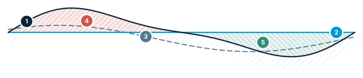
Cut / Fill — three reference modes
Same terrain, three references → three different volumes. The most confusing point for users.
- Existing terrain — the surveyed surface
- Flat level — a fixed design elevation
- Reference surface — another scenario or design
- Cut — above the reference → removed
- Fill — below the reference → added
1. Surface-to-surface (grid) volumes
The measured terrain is compared to a reference across a regular grid. At every cell the height difference is multiplied by the cell area; cells above the reference accumulate as cut, cells below as fill.
The reference can be a flat design level, another surface such as a design model, or an earlier survey of the same site. That last option — comparing two dated surveys — is how progress and monthly quantities are usually measured.
Strengths: it uses every cell of your data, handles complicated shapes without simplification, and gives you a cut/fill map, not just a total. Watch out for: the result inherits the resolution of your grid, and any noise or gaps in either surface go straight into the number.
2. Cross-section (average end area) volumes
Sections are cut perpendicular to an alignment at regular stations. The cut and fill area is measured on each section, and the volume between two neighbouring sections is the average of their areas multiplied by the distance between them.
This is the traditional method for roads, channels and trenches, and it is still the standard for payment quantities in most linear works — largely because it is transparent. Anyone can open the station table, check one section, and follow the arithmetic.
Strengths: auditable, produces the section drawings a construction set needs anyway, and matches how linear jobs are specified. Watch out for: it only samples the terrain at the stations, so features between them are averaged away. Tighten the spacing where the ground changes quickly.
3. Base-plane (stockpile) volumes
For a heap sitting on ground you cannot see, the reference is a base surface fitted under the pile — commonly a plane through the toe, or a surface interpolated from the surrounding terrain.
The material above that base is the stockpile volume. Multiply by a density and you have tonnage.
Strengths: fast, and the only practical approach when there is no pre-survey of the ground under the pile. Watch out for: the answer is only as good as the assumed base. On sloping or irregular ground the choice of base surface can move the result by several per cent, which is why the base should be stated in the report, not left implicit.
Why the same site gives different numbers
Two methods disagreeing is usually not an error — it is the two references disagreeing. A grid volume against a flat level and a cross-section volume against a design template are answering different questions.
Before comparing two figures, check three things: which reference surface each used, what resolution or station spacing each sampled at, and whether both cover exactly the same boundary. Differences almost always come from one of those three, in that order.
Choosing a method
Linear work — road, canal, pipeline trench — use cross-sections, because that is how the job is drawn and paid.
Area work — platform, pit, general earthworks — use surface-to-surface, because it captures the whole shape and gives a cut/fill map you can act on.
Loose material on unknown ground — use a base plane, and record which base you used.
For anything contractual, run the method the contract specifies. A more sophisticated method is not more correct if it answers a different question from the one you are being paid against.
| Method | Reference surface | Best for | Watch out for |
|---|---|---|---|
| Surface-to-surface (grid) | A flat level, a design surface, or an earlier survey of the same site. | Irregular shapes, progress between two dated surveys, and cut/fill maps. | The result inherits the grid resolution; noise or gaps in either surface go straight into the number. |
| Cross-section (average end area) | Sections cut perpendicular to an alignment at regular stations. | Roads, canals and trenches — and payment quantities that must be auditable. | It only samples at the stations; tighten the spacing where the ground changes quickly. |
| Base-plane (stockpile) | A base fitted under the pile: a plane through the toe, or a surface interpolated from the surrounding terrain. | Heaps with no pre-survey of the ground underneath. | On sloping or irregular ground the assumed base can move the result by several per cent — state it in the report. |
Frequently asked questions
Why do different people get different volume numbers for the same excavation?
Not because of a mistake, but because volume is always a difference between two surfaces (the current ground and a reference), not an absolute property of the ground itself — so different methods measured against different reference surfaces produce different, equally valid numbers.
What is the standard method for calculating volumes on road, pipeline, or other linear projects?
Cross-section (average end area) volumes: sections are cut perpendicular to the alignment at regular stations, the cut/fill area is measured at each section, and the volume between two neighbouring sections is the average of their areas multiplied by the distance between them. It remains the standard for payment quantities on most linear work because it is transparent and auditable.
How are surface-to-surface (grid) volumes calculated?
The measured terrain is compared to a reference surface across a regular grid; at each grid cell the height difference is multiplied by the cell area, with cells above the reference accumulating as cut and cells below as fill.
How do you calculate a stockpile's volume when there's no pre-pile survey of the ground underneath?
Use a base-plane method: the reference is a base surface fitted under the pile, commonly a plane through the toe of the pile or a surface interpolated from the surrounding terrain. On sloping or irregular ground, the choice of base surface can move the result by several per cent, so the base used should be stated explicitly in the report.
Is there an earthwork volume calculator that just gives the answer?
Only for shapes that are designed rather than measured. A calculator can close-form a trench or a pit with a flat floor and regular side slopes, because the geometry is known in advance. Real ground is not a known solid, so an earthwork volume has to be computed against a reference surface by one of the three methods above — which one you pick is set by the job, not by the arithmetic.
Sources
Calculate volumes in STREAM
Native Windows · fully offline · free beta