GRADING SOFTWARE
Grading Software for Platforms, Benched Slopes and Spoil Dumps
STREAM is grading software that takes an area you have already drawn on the terrain and brings it to a design elevation. It builds the benched slope that connects that platform to the existing ground, finds where the design meets the terrain, and returns the cut and fill quantities — on your own DEM, offline.
What is grading design?
Grading is the act of deciding what elevation a piece of ground should be at, and how its edges get there. A working platform, a quarry floor, a mine bench or a laydown pad all start the same way: pick the level, then design the slope that reaches the existing terrain.
The elevation you choose decides the earthwork. Set it too high and you fill; too low and you cut. Somewhere between the two is the elevation where cut equals fill and nothing has to be hauled on or off site.
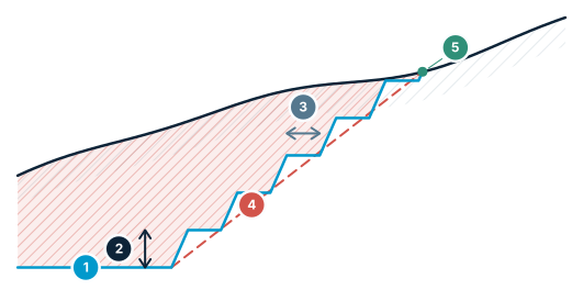
Benched slope — bench, berm, batter
Three numbers set the overall slope angle; where the design meets the ground is the daylight line.
- Platform level — the elevation the design is brought to
- Bench height — the vertical rise of one bench
- Berm width — the horizontal shelf left at the top of each face
- Overall slope angle — toe to crest — the angle geotechnical limits are written for
- Daylight line — where the design intersects the existing terrain
Grading Software in STREAM
Find the balance elevation
A curve plots volume against platform elevation: cut on one side, fill on the other. Where they cross is the elevation where the two balance. Drag the level and watch the quantities move, or jump straight to the balance point.
Benched slope templates
Set bench height, berm width and batter angle. Enter slopes in degrees or as 1:x, and choose which of the three the software derives from the other two — the derived field is locked so the set stays consistent.
Where the design meets the ground
The daylight line is computed as the intersection of the slope profile with the existing terrain, so the toe and crest follow the real surface rather than an assumed one.
Excavation or spoil dump
The same tool works in both directions. Design a cut platform with benched walls, or plan a spoil dump and read its capacity instead of its excavation quantity.
Checks that catch real mistakes
Overall slope angle against your limit, berm narrower than machine access needs, a slope that crosses itself at a re-entrant corner, a design that never daylights, partial last bench and the mass balance are all flagged with the value and the limit.
Apply it to the terrain
Write the design surface into the working terrain so contours, sections and later analyses read the graded ground — benches show up in the contour lines.
How to design a graded platform with benched slopes
- 1
Select the boundary
Choose the area you have already drawn on the terrain — the pit outline, the pad, or the footprint of the spoil dump.
- 2
Set the platform elevation
Enter the design level, or move it along the volume curve to the elevation where cut and fill balance and nothing has to be hauled on or off site.
- 3
Enter the bench geometry
Set bench height, berm width and batter angle, and choose which of the three is derived from the other two so the set stays consistent.
- 4
Review the checks
Overall slope angle against your limit, a berm too narrow for machine access, a slope that crosses itself, a design that never daylights and a partial last bench are all flagged with the value and the limit.
- 5
Apply to the terrain
Write the design surface into the working terrain so contours, sections and later analyses read the graded ground.
- 6
Export
Send plan and section drawings to DXF, quantity tables to Excel, and the design report with parameters and checks to PDF.
Supported formats
Frequently asked questions
What does STREAM's grading module do?
It brings an area you have drawn on the terrain to a design elevation, builds the benched slope that connects it to the existing ground, computes where the design daylights, and returns cut and fill quantities with drawings and a report.
How do I find the elevation where cut and fill balance?
STREAM plots cut and fill volume against the platform elevation. The point where the two curves cross is the balancing elevation, and you can move the design level straight to it instead of guessing and re-running the calculation.
Can I design mine benches and berms?
Yes. You set bench height, berm width and batter angle, and STREAM derives whichever of the three you choose from the other two, so the overall slope angle stays consistent with the bench geometry you entered.
Does it work for spoil dumps as well as excavation?
Yes. The module has a dump mode that plans a fill area and reports its capacity, rather than treating the design only as an excavation.
Does STREAM check slope stability?
No. STREAM checks the geometry of the design — overall angle against your limit, berm width, self-intersection, whether the slope daylights and the mass balance. Geotechnical stability analysis, such as a factor of safety, is outside its scope and remains the engineer's responsibility.
Try Grading in STREAM
Free beta for Windows x64. Works fully offline with GeoTIFF, LAS/LAZ and DXF.
Download STREAM free