DIGITAL SURFACE MODEL
DSM Software for Digital Surface Models
STREAM is DSM software that opens Digital Surface Models — the top surface including buildings, canopy and structures — and lets you measure, compute volumes and analyze them like any elevation grid, straight from GeoTIFF or a point cloud.
What is a DSM (Digital Surface Model)?
A Digital Surface Model (DSM) represents the top of everything on the ground — terrain plus buildings, trees and other objects. It differs from a DTM (bare earth) and is often what you get first from photogrammetry or LiDAR.
DSMs are ideal for volumes of piles and structures, line-of-sight and canopy work. STREAM builds a DSM from all points of a cloud, or opens one directly.
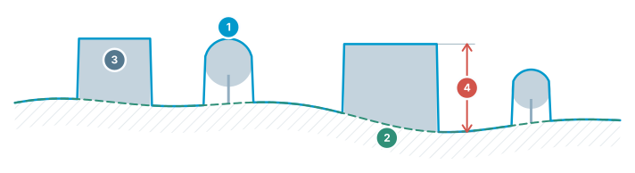
DEM / DSM / DTM
Three different surfaces of the same terrain — which one to use, at a glance.
- DSM — top surface — includes buildings, trees and structures
- DTM / DEM — bare earth — real ground with objects removed
- Objects — present in the DSM, absent in the DTM
- Difference = object height — building/tree height comes from this gap
DSM Software in STREAM
Open or build a DSM
Open a DSM from GeoTIFF, or build one from all points of a LAS/LAZ cloud on import.
Volumes on the surface
Measure stockpile and cut/fill volumes on the surface model, above buildings and piles.
Surface analysis
Run slope, viewshed, line-of-sight and sun & shadow on the DSM — where the top surface matters.
Compare with a DTM
Use a DSM alongside a bare-earth DTM to separate objects from terrain.
How to work with a DSM in STREAM
- 1
Load the surface model
Open the DSM GeoTIFF, or build one from all points of a LAS/LAZ cloud during import.
- 2
Confirm the coordinate system
Check the CRS as the layer is added so the DSM aligns with any DTM or orthophoto already loaded.
- 3
Inspect in 3D
Switch to the 3D view to see buildings, vegetation and structures standing on the surface.
- 4
Compare against bare earth
Put the DSM alongside a bare-earth DTM; the difference between the two is the height of everything sitting on the ground.
- 5
Measure or export
Take heights and profiles directly off the surface, and export the result as GeoTIFF when it goes back to GIS.
Supported formats
Frequently asked questions
What is the difference between a DSM and a DTM?
A DSM (Digital Surface Model) includes buildings and vegetation — the top surface. A DTM (Digital Terrain Model) is bare earth. STREAM opens and builds both.
Can STREAM build a DSM from a point cloud?
Yes. STREAM builds a surface model from all points of a LAS/LAZ cloud on import, and a bare-earth model from ground-classified points.
Can I compute volumes on a DSM?
Yes. Stockpile and cut/fill volumes work on the surface model, which is ideal for piles and structures.
Where this is used
Try DSM in STREAM
Free beta for Windows x64. Works fully offline with GeoTIFF, LAS/LAZ and DXF.
Download STREAM free