DIGITAL TERRAIN MODEL
DTM Software for Bare-Earth Terrain
STREAM's DTM software builds a clean bare-earth Digital Terrain Model (DTM) from ground-classified points, or opens an existing DTM from GeoTIFF, and turns it into the base for volumes, cross-sections, contours and analysis.
What is a DTM (Digital Terrain Model)?
A Digital Terrain Model (DTM) is the bare-earth surface with buildings and vegetation removed. It is the reference most engineering work needs — earthworks, drainage, contours and grading are all built on the terrain, not the objects on it.
STREAM derives a DTM from ground points and computes on it directly.
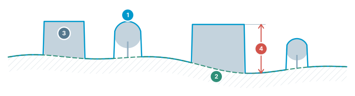
DEM / DSM / DTM
Three different surfaces of the same terrain — which one to use, at a glance.
- DSM — top surface — includes buildings, trees and structures
- DTM / DEM — bare earth — real ground with objects removed
- Objects — present in the DSM, absent in the DTM
- Difference = object height — building/tree height comes from this gap
DTM Software in STREAM
Bare-earth from points
Build a clean DTM from ground-classified points of a LAS/LAZ cloud, automatically on import.
Earthwork on the terrain
Cut/fill, cross-section cubature and stockpiles run on the bare-earth surface for correct engineering quantities.
Contours & drainage
Generate contours and run hydrology on the DTM to model the real ground shape and flow.
Open GeoTIFF DTMs
Already have a DTM? Open it directly from GeoTIFF and start measuring.
How to get a bare-earth DTM in STREAM
- 1
Start from the ground points
Import the LAS/LAZ cloud and build the terrain model from the points classified as ground, or open a DTM GeoTIFF you already have.
- 2
Set the grid resolution
Choose the cell size the ground points are sampled onto — this becomes the resolution of every quantity computed later.
- 3
Check the surface
Look at the result in 3D and against the orthophoto to confirm that buildings and vegetation are gone and the ground reads correctly.
- 4
Use it as the base
Volumes, cross-sections, contours, slope and hydrology all run on this bare-earth surface.
- 5
Export
Save the DTM back out as GeoTIFF for GIS, or the derived contours and sections as DXF for CAD.
Supported formats
Frequently asked questions
How does STREAM create a DTM?
STREAM builds a clean bare-earth DTM from ground-classified points of a LAS/LAZ cloud on import, or opens an existing DTM from GeoTIFF.
Why use a DTM instead of a DSM for earthworks?
Earthwork quantities should be measured on the bare-earth terrain, not on buildings or vegetation, so a DTM gives correct cut/fill and grading results.
Can I generate contours from a DTM?
Yes. STREAM generates contours at any interval directly from the DTM and exports them as editable DXF vectors.
Can STREAM convert a DSM to a DTM?
Not by classification: STREAM does not classify points or filter a surface model into bare earth by itself. A DTM comes from the ground class of a LAS/LAZ cloud, or from the software that produced the data. On a DSM, STREAM offers corrections instead — remove an object with one click, or the objects found inside a drawn area once you approve them — and the low-pass pattern of the Dot tool, which takes the lowest spot around each grid point. Triangulated, those points give a ground approximation; check it against the orthophoto before using it for quantities.
Where this is used
Try DTM in STREAM
Free beta for Windows x64. Works fully offline with GeoTIFF, LAS/LAZ and DXF.
Download STREAM free