EXPORT
Export to DXF, GeoTIFF, CSV, KMZ and LandXML
Analysis is only useful if it leaves the app cleanly. STREAM exports to the formats your downstream tools expect — DXF for CAD vectors, LandXML when the receiving software needs the surface itself rather than a drawing of it, CSV for coordinate tables, GeoTIFF for georeferenced rasters, KMZ for Google Earth and PDF for print-ready reports.
Deliverables, not dead ends
Every result in STREAM — vectors, contours, cross-sections, analysis layers, volumes — is built to be exported, so it flows into CAD, GIS and reports without manual rework.
Georeferencing is preserved on export, so rasters and vectors land correctly in the receiving tool.
Export (DXF, GeoTIFF, CSV, KMZ) in STREAM
DXF for CAD
Export vectors, contours and cross-section drawings to DXF, keeping layers, for use in CAD.
LandXML surfaces
Export a triangulated surface as a LandXML 1.2 Surface, with survey points as CgPoint and the coordinate system written into the file — the topology DXF cannot carry.
GeoTIFF rasters
Export analysis results and cut/fill heat maps as georeferenced GeoTIFF for GIS.
CSV tables
Export coordinates, points and measurement tables as CSV for spreadsheets and reports.
PDF reports
Produce print-ready PDF reports for stockpile volume and change detection.
One export gate, one folder
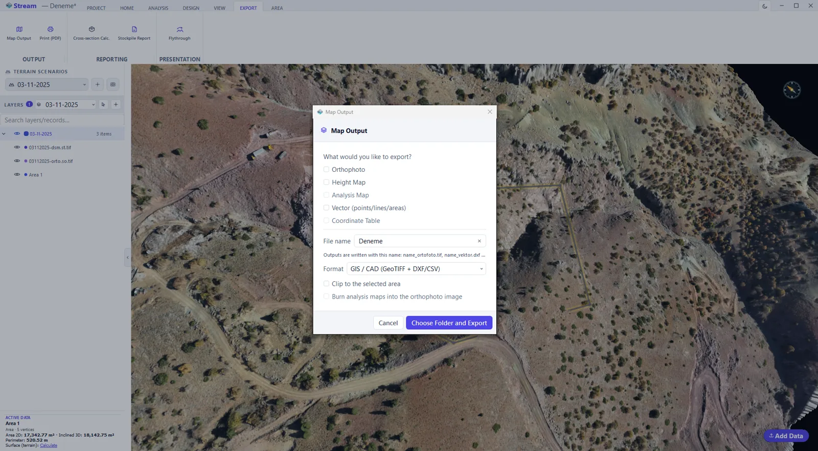
Map Output is the single door out: tick the orthophoto, elevation map, analysis map, vectors and point table you want, pick GIS/CAD (GeoTIFF + DXF/CSV), Google Earth (KMZ), LandXML or Shapefile, and every file lands in one folder. You can clip to a selected area and burn the analysis maps into the orthophoto image.
How to get results out of STREAM
- 1
Decide what the deliverable is
A drawing for CAD, a raster for GIS, a table for the quantity surveyor, or a report for the client — each has its own route out.
- 2
Export drawings to DXF
Vectors, cross-sections, contours and design geometry go to DXF with their layer structure intact.
- 3
Export rasters to GeoTIFF
Analysis results, cut/fill maps and cropped extents export as georeferenced GeoTIFF.
- 4
Export tables to CSV or Excel
Station-by-station quantities, hole tables and coordinate lists come out as CSV or Excel.
- 5
Produce the report
Build the map sheet and the print-ready PDF report, or a KMZ when the result has to be viewable outside the office.
Supported formats
Frequently asked questions
What formats can STREAM export?
DXF for CAD vectors and drawings, LandXML 1.2 for triangulated surfaces and survey points, GeoTIFF for georeferenced rasters, CSV for tables, KMZ for Google Earth, and PDF for stockpile and change-detection reports.
Is georeferencing kept on export?
Yes. Exported rasters and vectors keep their coordinate system so they land correctly in the receiving tool. LandXML additionally writes the coordinate system into the file itself.
Can I export cross-section drawings?
Yes. Cross-section drawings export to DXF, alongside the cubature (volume) table.
Why export LandXML instead of DXF?
Because DXF carries a drawing, not a surface. A DXF exported from a triangulated model is a set of lines and faces with no topology and no declared coordinate system, so the receiving software has to rebuild the surface and be told where it sits. LandXML writes the triangulation as a Surface and the coordinate system as part of the file, which is why survey and civil packages can open it as a surface directly.
Can STREAM open or import a LandXML file?
Yes, LandXML 1.2 works both ways. A Surface definition opens as a TIN surface, CgPoint elements become points, and PlanFeature or CoordGeom becomes a line — or an area when the last vertex closes back on the first. If the project has no coordinate system yet it is taken from the file; if it has one that differs, STREAM warns rather than silently transforming the geometry.
What else can STREAM import besides rasters and point clouds?
CAD and GIS vectors: ASCII DXF from R12 to R2007 and later, ESRI Shapefile, GeoJSON and GeoPackage, plus CSV and TXT point files, LandXML, and block model tables as CSV, TXT, DAT, ASC or XLSX. A GDAL virtual raster (.vrt) is recognised alongside GeoTIFF. DWG and binary DXF are not read — save as ASCII DXF from your CAD package — and OBJ, PLY and STL have no import path.
What happens to attributes in a Shapefile, GeoJSON or GeoPackage?
Every OGR layer becomes a layer and every feature becomes an object with the same selection, snapping, styling and export rights as anything drawn in STREAM. The attribute table is readable per object from the layer tree; DXF carries no such table, so it comes up empty there.
Can I burn an analysis map into the orthophoto?
Yes. Map Output has an option to render the analysis maps onto the orthophoto image, so the colour map travels as part of the georeferenced orthophoto. It can also clip the export to a selected area.
How do I convert a DXF to a Shapefile?
Import the DXF, then open Map Output and choose Shapefile. STREAM writes the points, lines and areas as separate .shp files — a Shapefile holds one geometry type — with a .prj whenever the coordinate system resolves to an EPSG code. A layer with very many objects loads read-only for speed; right-click it and choose Make Editable first so its objects are exported too.
Try Export (DXF, GeoTIFF, CSV, KMZ) in STREAM
Free beta for Windows x64. Works fully offline with GeoTIFF, LAS/LAZ and DXF.
Download STREAM free