VECTOR TOOLS
Vector Drawing Tools on the Terrain
STREAM's vector drawing tools let you draw points, lines and areas that sit directly on the terrain surface. Sketch them over your DEM and imagery, organize them in layers, and export the result to CAD.
Vectors that follow the ground
Vector objects in STREAM are draped on the DEM, so a line follows the terrain and a point sits at its true elevation. That keeps drawings consistent with the surface they describe.
Layers keep the drawing organized, and snapping keeps it precise.
Vector Drawing Tools in STREAM
Point, line & area
Draw vector points, lines and areas that sit on the terrain, organized into named layers.
Snapping & precision
Snap to existing features so drawings connect cleanly and stay precise.
Surfaces from vectors
Triangulate selected points, lines and areas into a TIN surface, or trace a contour as an area.
Export to DXF
Send your vector layers to DXF for CAD, keeping the layer structure.
Ortho, polar and grid
Ortho locks a segment to 0, 90, 180 or 270 degrees; polar locks it to angle steps of 5, 10, 15, 30, 45 or 90 degrees (15 by default); grid snap rounds the cursor to a spacing from 0.5 to 25. Ortho and polar exclude each other, grid works with either, and snapping to an object always wins over the constraint.
Type the length and angle
While a line is being drawn, a length box sets the segment's plan length and an angle box sets its direction (0 is east, counter-clockwise). A typed angle overrides ortho and polar; leave the length empty and the cursor decides.
Undo that knows what it undoes
Ctrl+Z and Ctrl+Y step through 64 actions, and the button names the action it will undo. One action is one step: a DXF import or a bulk delete comes back with a single Ctrl+Z.
Line editing
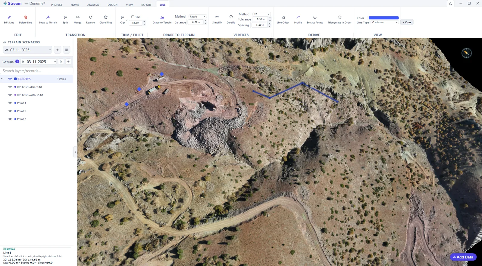
Split a line where you click, join two lines into one, simplify away vertices within a tolerance, densify by adding vertices at an interval while keeping the existing ones, or close a line into a ring once it has three vertices. Fit to Terrain samples the surface along the line at a spacing you set.
Trim, extend and fillet
Trim removes the piece of a line you click, up to the nearest intersections on either side; Extend lengthens the end you click until it meets another line; Fillet rounds a corner with an arc of the radius you type. Where there is no intersection the line is left unchanged and the reason is shown.
Area tools
Draw an area vertex by vertex or as a box or circle. Follow Elevation turns one click on the terrain into the closed contour at that level as a flat area, and Dot covers an area with points on a triangular, rectangular or low-pass pattern at a spacing you set. Cut and fill between a TIN and the terrain is Volume vs Model, on the TIN's own tab.
Select by area
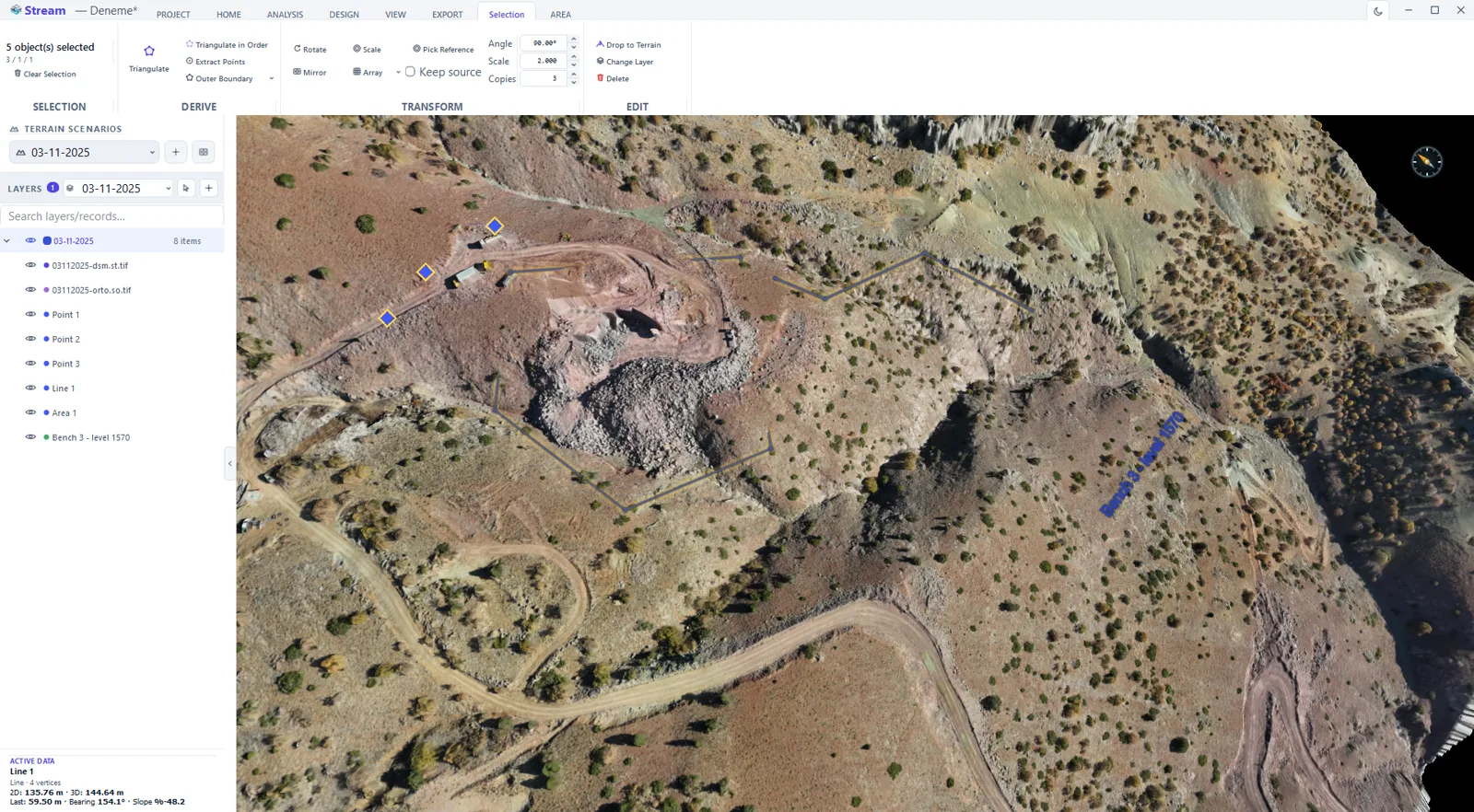
Drag a box to select every point, line and area inside it, hold Ctrl to add to the selection, or select all and invert. A selection gets its own tab: drop it to the terrain, triangulate it, extract its vertices as points, change its layer or delete it.
In the product
How to draw vectors on the terrain
- 1
Pick the tool
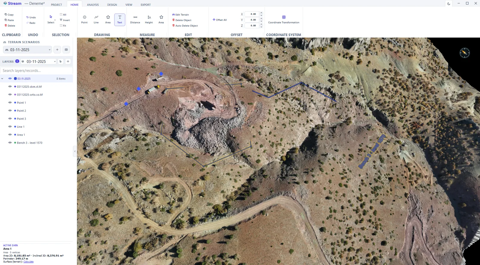
Point, line or area. Left click adds a vertex, double click or right click finishes, Esc cancels — and Ctrl+Z undoes across drawing, measurement and terrain edits alike.
- 2
Draw on the surface
Vertices land on the terrain and take their elevation from it, so the geometry is three-dimensional from the first click.
- 3
Use the contextual ribbon
As soon as a geometry is active its own tab appears with every command that applies to it — drape to terrain, simplify, offset, triangulate, follow an elevation.
- 4
Organise into layers
Give each vector a layer, colour and visibility so the drawing stays readable as it grows.
- 5
Export
Send the vectors to DXF for CAD keeping the layer structure, or to CSV when you need the coordinates as a table.
Supported formats
Frequently asked questions
Do vectors follow the terrain?
Yes. Points, lines and areas are draped on the DEM, so they sit at true elevation and follow the surface.
Can I export vectors to CAD?
Yes. STREAM exports vector layers to DXF, keeping the layer structure for CAD.
Can I build a surface from vectors?
Yes. STREAM triangulates selected points, lines and areas into a TIN surface, and can trace a contour as an area.
Can I draw at exact angles?
Yes. Ortho locks lines to the four axes, polar locks them to steps of 5 to 90 degrees, and you can also type the angle directly while drawing. Snapping to an existing object takes priority over both.
Can I type an exact segment length?
Yes. A length box appears while you draw; the value you type is the plan length of the segment. Left empty, the length follows the cursor projected onto the locked direction.
How far back can I undo?
64 steps. Each action is one step, the undo button tells you which action it will reverse, and Ctrl+Y redoes it until you make a new change.
What is the difference between simplify and densify?
Simplify removes vertices that add nothing within the tolerance you set. Densify keeps every existing vertex and adds new ones between them at the interval you set — useful before draping a long straight segment on the terrain.
Can I turn an elevation into a closed area?
Yes. Follow Elevation takes one click on the terrain and draws the closed contour at that level as an area with a flat elevation.
How do I select many objects at once?
Drag a box with Select by Area, or hold Ctrl and click. Ctrl+A selects everything and Invert flips the selection.
Can points carry a name or number?
Yes. Every point has a name. When a CSV or TXT point file is imported, its name column is read; points without one are named automatically.
Can I sample terrain elevations on a regular grid?
Yes, with Dot. Select an area and set a spacing: Dot fills it with points on a triangular or rectangular grid, each taking its elevation from the terrain, and puts them on a layer of their own; points that would fall outside the DEM are left out. The low-pass pattern instead moves each point to the lowest spot within a quarter of the spacing, so it tends to land on the ground beside a bush or a stone rather than on top of it. The points export to CSV or DXF like any other points, or can be triangulated into a TIN.
Can I offset a line sideways and up or down — for a curb or a ditch edge?
Yes. Line Offset makes a parallel of the selected line to the Right or Left at the horizontal distance you type, and can shift its elevation (Z) at the same time — or drag it on the map, holding Shift to change the elevation. Create as copy keeps the original; Both sides offsets in both directions at once. Draw the back of a curb, then offset it for the face and the gutter line; Area Offset does the same for a closed area, outward or inward.
Can I digitize planimetric features from the orthophoto?
Yes. With the orthophoto shown, draw points, lines and areas over what you see — road edges, building outlines, fences, manholes — on named layers. Every vertex takes its elevation from the terrain, so one drawing serves as both the planimetric map and a 3D line set, and it goes to CAD as DXF with its layers.
Try Vector Drawing Tools in STREAM
Free beta for Windows x64. Works fully offline with GeoTIFF, LAS/LAZ and DXF.
Download STREAM free